AGNER ascent
FERRATA STELLA ALPINA
Approach
Suggested starting point: Rifugio SCARPA Agner
Suggested arrival point: Rifugio SCARPA Agner
Difficulty EEA - II - PD- AR
Duration 3:00/4.00 h (ascent only)
Elevation gain D+ 1.150 m
Highest point 2.872 m MONTE AGNER
Lowest point 1.735 m Rifugio SCARPA Agne
Maps
Cartography: carta TABACCO 022
ATTENTION: Until the end of July there is usually still a lot of snow inside the couloir. For this reason it is recommended to have a pair of crampons and an ice ax with you.


OVERVIEW
Beautiful climb to the highest peak on this side of the Pale di San Martino. A very broad panorama along a challenging but extremely satisfying climb.
ITINERARY DESCRIPTION
To climb Mount Agner you need to reach the Biasin bivouac at an altitude of 2650 m, from here the last part of the normal route starts. To reach the bivouac there are three possible routes: the normal route, the couloir route, and the Stella Alpina via ferrata.
From the refuge continue past the stable and Malga Losch until you reach a crossroads with many signs. Continue along the unmarked path that steeply climbs the hill behind the hut (via ferrata indications on a yellow sign). Continue on the path from Malga Losch for about 10 minutes until you reach a crossroad: on the left the path for the via ferrata Stella Alpina and the Via del Canalone, on the right the normal route (sign: Minussi path).
Take the left and follow the red and yellow (mostly yellow) signs. You walk under the clearly visible yellow-black wall to the left of the snow-covered gully, following the yellow-red marks; you branch off from the path to the left and go uphill until you enter a gorge with steep walls. It is advisable to wear a helmet and via ferrata material at the entrance to the gorge because you climb up the right side (orographic left) of the gorge thanks to a steel rope.
After passing the right shoulder, go up following the stamps and signs (unequipped path) up to what is the real start of the via ferrata with a stone falling danger sign.
The via ferrata begins from here which is immediately challenging and then remains on medium challenging levels of difficulty (exposure, verticality and difficulty on rock), until the end where it becomes more difficult (especially the last meters with a slightly overhanging slab equipped with 3 bolts to facilitate the steps).
The exit of the via ferrata is not pointed out, you find yourself on a rocky plateau with a beautiful view of the SCARPA refuge, Agner and the Lastei peaks.
From the start about 1h30'.
Following the stonemen and signs (red and yellow) you arrive at a plate that is not too difficult to cross to the left (regular alpine equipment for hooking up) until you reach a clear red circle with the number 2 (probably an air rescue point). From here you always go up on a grassy and rocky track following stonemen and signs.
The route is always uphill and tends to traverse to the right (going up) towards the clearly visible Biasin bivouac (high up on the fork). Pay attention to the stonemen that mark the limits of the steep couloirs you encounter (the crossing of one of these is also equipped with a steel cable).
Still following the red-yellow signs, you go slightly down and then head decisively uphill inside a detrital couloir that leads to the Pizzon fork. This must be abandoned almost at the end to exit from the right side (going up) (important in case of low clouds or poor visibility: do not follow the couloir up to the Pizzon pass or, even worse, go up the rocky hill on the right (elevation 2698 m) as the bivouac is located on the fork following the Pizzon and the descent from the bivouac side is particularly risky).
The path continues well marked, losing altitude up to a series of metal cables that lead you around altitude 2698 and then up the detrital couloir to the right of the same altitude, up to the bivouac. From the exit of the via ferrata approximately 1h 30'.
Up to here 3 hours.
FROM BIVOUAC BIASIN TO THE SUMMIT
Climb to the top from the Biasin bivouac: right behind the bivouac, metal cables immediately begin which lead you up and across to the left. Three or four very exposed sections follow each other in rapid succession (one of which is downhill). At the end of the last stretch the ropes end inside a small channel; on the left you can see two sloping rocky ramps: the upper one is very wide and steep, the lower one is narrower and less steep. You must exit the couloir (5 m) and continue for a few meters on the lower ramp and then turn right and with a narrow zig-zag on rocks (I+) move to the upper ramp. Be careful with poor visibility not to be tempted by the lower ramp as it falls into the void between the N face of the Agner and the Armena Tower. Go up the upper and very wide ramp for approximately 20 m of altitude difference. Once out of the ramp, turn right following a red mark but you will find yourself in front of a crack about 80 cm wide and several tens of meters deep. Climb up keeping to the right of the crack on a narrow ledge (very exposed), continue for a few meters until you find a comfortable point to pass to the other side with a firm step. Still without seeing any stamps or signs, you must climb up the small wall of about 15 m against which you are leaning (climbing to the left of the crack) with passages of II. Once out of the small wall you can once again glimpse signs and cairns and a metal rope. Climb up along tracks and rocks until you come across a stretch of metal cable that allows you to reach the ridge that leads to the top. Once you have left the equipped section, you go up again along tracks (marks and clearly visible cairns) and I+ passages until you reach the summit of Mount Agner with a wooden plaque.
From bivouac to the summit: 45 min
DESCENT:
The same as the climb until the bivouac. The via ferrata downhill is not recommended, the choice is between the normal route and the couloir route (if you choose the couloir route, do not abandon the path and be misled by dubious red paint signs, but follow the entire route to the end. Pay attention to the snowfield which at a certain point on the descent might seem like a rapid descent route; in reality it has notable slopes, emerging stones, crevasses).
PLEASE NOTE:
Pay great attention to the weather conditions: absolutely avoid in case of bad weather and with poor visibility. In particular, the last part to the top poses orientation difficulties and requires attention.
As regards the via ferrata (but also the couloir route), the risk of falling stones is particularly high due to the not always good rock and the verticality of the route.
Please be always careful in moving stones that could hit people waiting to start the via ferrata.
A piece of rope is useful for securing.
The difficulty described in the report relates to the climb along the normal route, the via ferrata has very athletic passages and is generally challenging, while the couloir features III+ sections alternating with easy or walking sections.
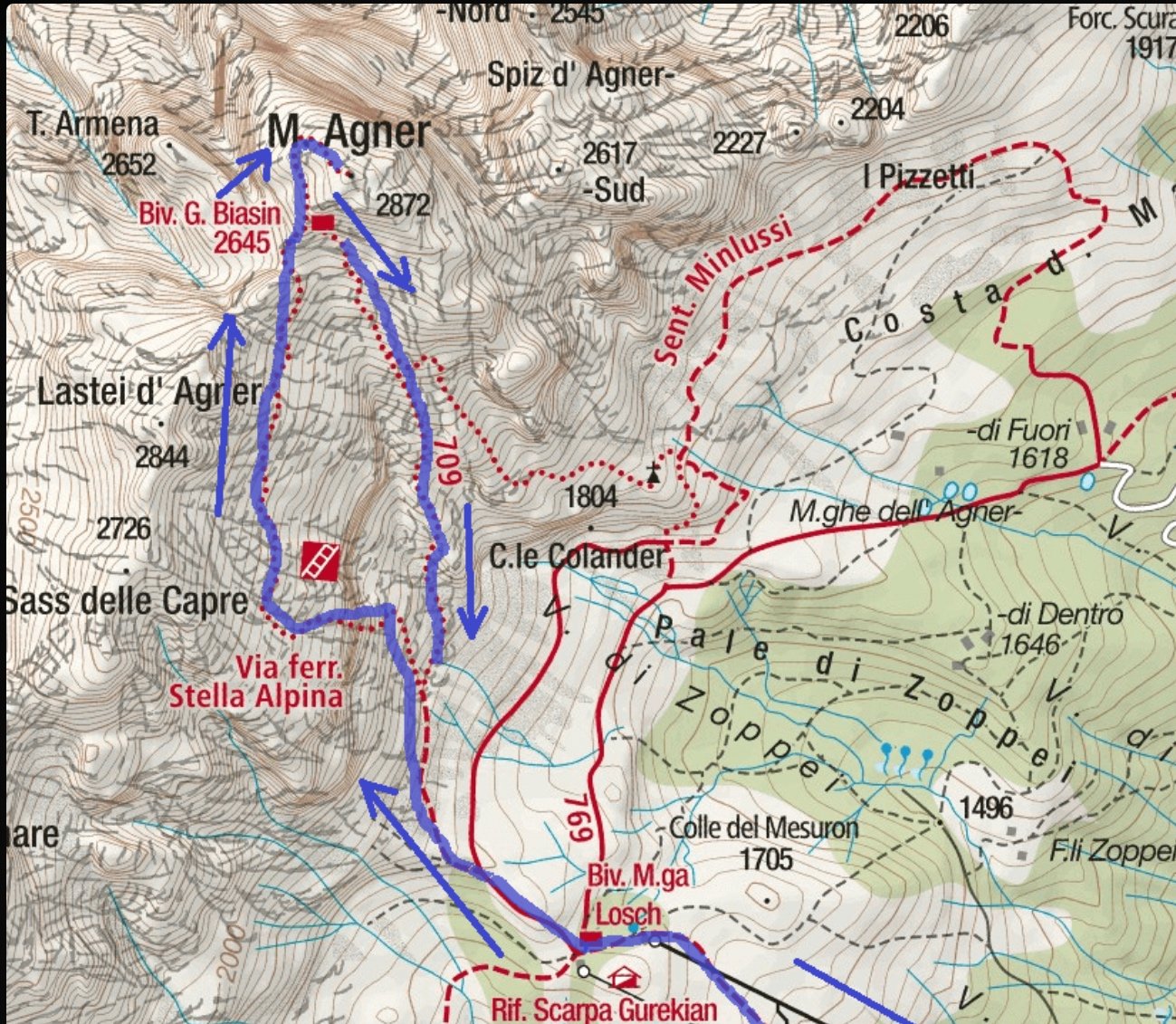
ROUTE MAP